
Podcast: Play in new window | Download
Subscribe: Apple Podcasts | RSS
 Born in France, 22-year-old Claude-Joseph Désiré Charnay became a teacher in New Orleans. The year was 1850. In the US before the Civil War the press was abuzz with reports of strange lost cities in the jungles of Mexico and Central America. The young Charnay was captivated by the works of John Lloyd Stephens, specifically his detailed travel material coming out of the Yucatán. Charnay would make several journeys to Mexico, once even with French troops under the leadership of Emperor Maximilian. On his 1880 trip, Charnay would explore a very unusual ruined site in the Mexican state of Tabasco. The lost city was called Comalcalco, after the small village of the same name that stood near the ruins. As the first person to make Comalcalco known to the outside world, Charnay published his findings in the October 1881 edition of The North American Review. While Charnay mistakenly identified the ruins as Toltec he did note similarities between Comalcalco and Palenque, a city he had visited over 20 years before. In The North American Review piece Charnay described the vast site and its very unusual construction:
“The pyramid is composed of baked bricks mixed with earth, and the buildings, on a plain where there is not the least gravel, are also constructed of baked bricks set in mortar that is made of lime. The walls seem to me thicker than those at Palenque, and the construction altogether quite as solid, as was evidenced by the great masses of masonry that have fallen without breaking.”
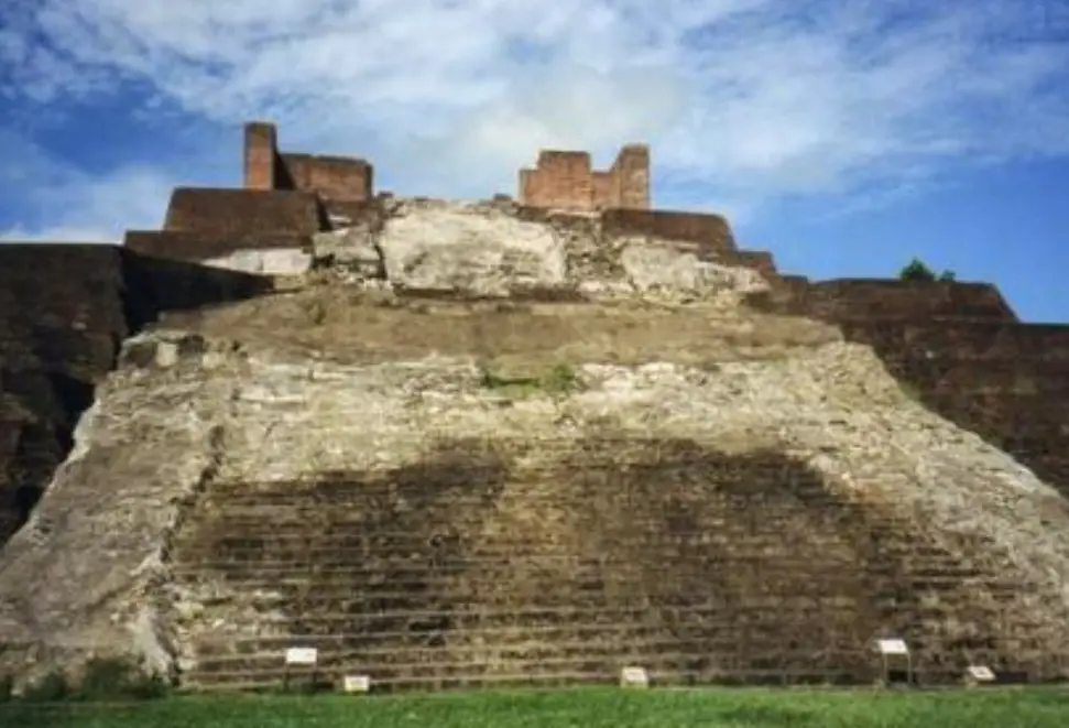
The dark red baked brick construction of the buildings noted by Charnay make Comalcalco unique in the Maya world. As the westernmost known ancient Maya site, Comalcalco has many other fascinating features.
Although the city was inhabited by the Maya, the name Comalcalco comes from Nahuatl, the language of the Aztecs. Comalcalco is a combination of two words, “comalli” which is a flat cooking stone, or griddle, and calli, meaning “house”. The locative “co” is added so that the full name might read, “At the House of the Flat Cooking Stones.” The bricks used in the construction of the site were reminiscent of Mesoamerican comales or cooking stones, so that gave rise to the name. As of a few decades ago, we know the name that the Maya themselves called this place, lifted from a name glyph found there and at two other places. They called Comalcalco “Hoi Chan” or, the “Place of the Rounded Sky.”
 People started settling at the site of Comalcalco around the year 300 BC most likely to take advantage of the natural resources of the Mezcalapa River floodplain, and to capitalize on a trade route developing between the coast and interior. The area is very dense in cacao trees, and cacao production and distribution must have been important economic activities from the early days of the city. For more information about the importance of cacao in ancient Mexico, please see Mexico Unexplained Episode number 267 https://mexicounexplained.com/cacao-from-currency-to-chocolate/ The first buildings at Comalcalco were made of packed earth coated with stucco and painted red. A second mode of construction, known as Phase Two, began around 400 to 500 AD, during the Early Classic Period, and consisted of kiln-fired bricks. Comalcalco is the only Maya site made with clay bricks instead of cut limestone. The bricks were not molded but cut out of blocks of clay. Many of the millions of bricks used at Comalcalco have inscriptions on them which has given rise to much speculation and even a few fringe theories. Some researchers, for example, have claimed that some of the bricks have inscriptions in Old World languages from ancient Egyptian to Arabic, to Burmese and Chinese. Unfortunately, there is no tangible proof for us to examine, just hearsay, accompanied by the usual theories of official government suppression and denial. In any case, the bricks at Comalcalco leave behind a treasure trove to be studied. Many archaeologists do not know what purposes these decorations and writings on the bricks served. To form into buildings, the bricks were joined by mortar comprised of calcinated oysters and seashells from the nearby Mecoacan Lagoon. Again, this type of mortar is a unique building material found nowhere else in the Maya world, as every other Maya site used crushed limestone as mortar. The many kilns used to fire the bricks used in construction were also used to fuel Comalcalco’s arts and crafts industry, specifically, the making of clay figurines. Using chemical analysis, archaeologists have determined that Comalcalco figurines were being traded hundreds of miles away during the height of the city’s power. Figurines appear to have served a wide range of uses and have been found in many different archaeological contexts, from elite burials to excavations of ordinary households.
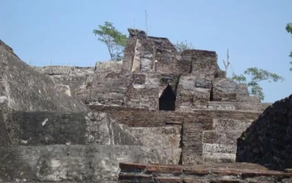
 With the graffiti and more elaborate drawings on the bricks and all the formal art that survives on the monumental architecture at Comalcalco, archaeologists are slowly piecing together a detailed history of this enigmatic place. Although the city had been established hundreds of years before then, the earliest date found in any inscription reads August 10, 561 AD, and references a ruler named Chan Tok I. Comalcalco had its own independent royal family and noble class ruling for generations until the city was conquered by nearby Tortuguero on December 20, 649 AD. The stone monuments of Tortuguero record the capture of the Comalcalco king called Ox Balam by the Tortuguero ruler Balam Ahau. After this, Comalcalco started using the name glyph of Palenque which was also ruling over Tortuguero at the time. It was after this crushing defeat that the Palenque architecture that the French explorer Charnay noted so prevalent there began to make its appearance at the site. It’s unknown if a new nobility was installed at Comalcalco after the historic defeat, but the city still had local rulers and administrators. The last known record of a ruler dates to March 7, 814 AD, and it is associated with a man called El Kinich, which translates to “Burnt Sun.” Like so many other Maya sites, Comalcalco was abandoned in what archaeologists call the Terminal Classic, sometime between 900 AD and 1100 AD. While the collapse of classic Maya civilization still remains somewhat of a mystery, researchers have discovered at Comalcalco’s Temple II, references to rituals related to rain deities dating from the late 700s and early 800s AD. A severe drought hitting the Maya homeland in the late 8th Century could have contributed to the disintegration of the social fabric and may have been one of the many stressors that eventually led to the collapse of the whole system.
Excavations began at Comalcalco in 1880 with the arrival of Charnay who was more interested in making finds he could ship off to museums and collectors in the US and Europe. Local Mexicans started digging at the site in the 1890s, but formal archaeological work only really began in 1925 under the supervision of Danish archaeologist Frans Blom and his associate Oliver LaFarge, an American. The Mexican government became interested in the site in the 1960s and set up a plan to open up Comalcalco to tourists. As the Comalcalco is only 25 miles from Villahermosa, the capital city of the state of Tabasco, the ruins see many visitors. A beautiful modern museum opened on site in 2012.
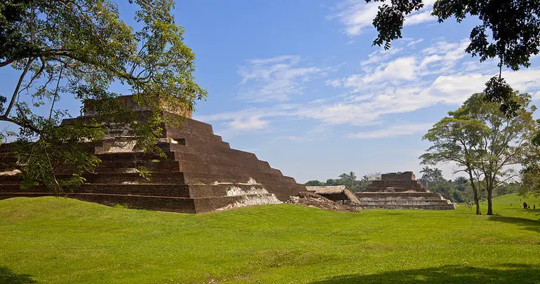
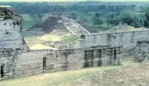
 As already mentioned, anyone visiting Comalcalco will be taken by its unique architecture made of brick. Although most of the site remains unexcavated, there are over 430 structures that have been identified so far. Although the site sits on some 178 acres, the central core is dense with buildings, and is divided into 3 distinct zones: North Plaza, the Great Acropolis, and the East Acropolis. Running east to west, the North Plaza is flanked by terraces and is dominated by a 66-foot-tall brick pyramid known as Temple I. On these terraces are smaller temples and other public buildings. Between two structures known as Temple IIIa and IIIb on the southern part of the plaza, a gap exists leading into the Great Acropolis. The Great Acropolis is comprised of a massive artificial platform rising to 115 feet in height topped by a diverse set of buildings with some interesting descriptive names: The Temple of the Seated Chieftains, the Temple of the Mask, the Stucco Tomb, the Tomb of the Nine Lords of the Night, and the Palace. The Palace, not fully restored at this time, was the largest building at the Great Acropolis and must have served some important religious purpose as many altars have been discovered inside the ruins of the building. The Sunken Patio Group is located at the Great Acropolis’ southeast exit and may have been the home to elite residences. On the western end of the Great Acropolis are the remains of Comalcalco’s main ball court, waiting for thorough restoration. To the east of the Great Acropolis is the aptly named East Acropolis. This is a smaller version of the Great Acropolis with very similar temple structures but with no brick buildings immediately visible. In 2010, an archaeological team excavated three mounds located almost 2 miles north of the Great Acropolis. In those mounds they found 116 sets of skeletal remains. Out of those 116 individuals, 66 were identified as being elites as they had some of the signature identifiers of the Maya ruling class: cranial deformation, ornamental tooth inlays and tooth fillings. The burial dates to around 800 AD and was one of the largest and most extensive ever uncovered in the Maya world. Given the number of inscriptions still uncatalogued on its bricks, and given the fact that only a fraction of the site of Comalcalco has been properly excavated, it would take 100 archaeologists working 100 years to get a complete view of this complex place. For now, much of this lost city of brick remains a mystery.
REFERENCES
INAH Web site