
Podcast: Play in new window | Download
Subscribe: Apple Podcasts | RSS
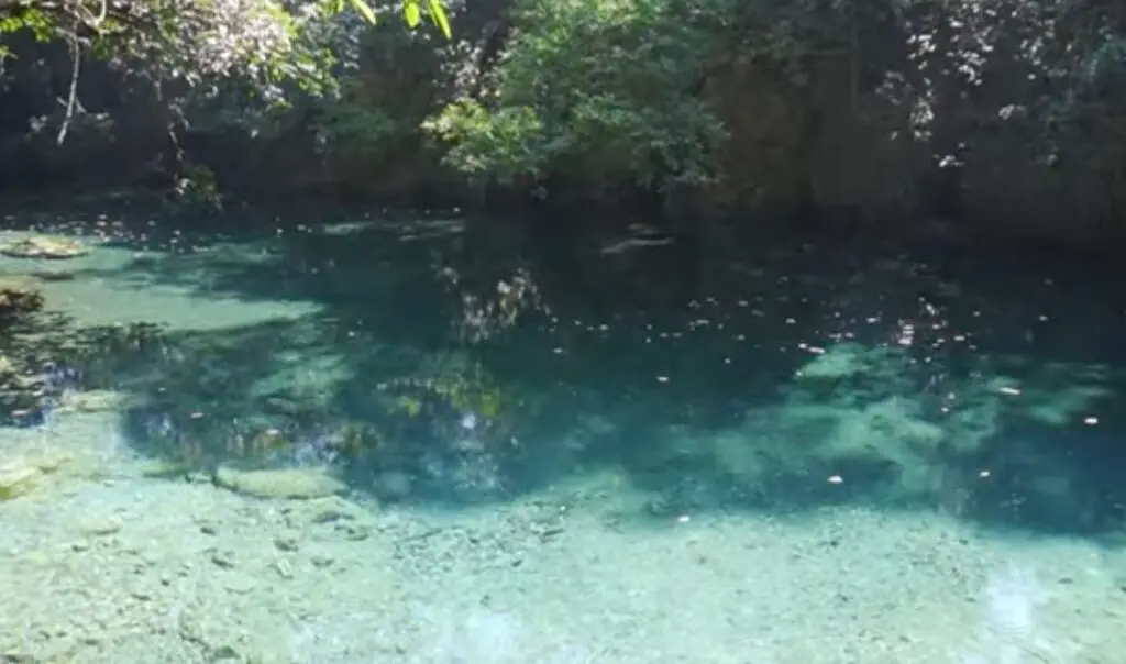
 While journeying through Central America and across the extreme southeastern part of Mexico in the year 1840, American adventurer John Lloyd Stephens stumbled upon a unique “lost city” built amid a series of beautiful turquoise-blue lakes and ponds. Stephens kept detailed logs of his travels that were later published, and he described the area as “a wild place of incomparable beauty.” Most of the city, now known as Lagartero, or “The Place of the Lizard,” was covered by vegetation with locals using the lakes and streams surrounding the crumbling ruins for swimming or fishing, much as they do today. As Stephens had visited many larger archaeological sites in his travels, Lagartero remained just a footnote and it was ignored by the outside world for many more years. It is interesting to note that Stephens’ brief mentioning of this interesting but obscure city was not the first in the English-speaking world. Some two centuries before Stephens set foot in Mexico, an Englishman named Thomas Gage visited Lagartero on his way to Guatemala in 1628. Specifically, he noted the teal-blue mineral springs that locals believed had miraculous healing powers. Gage would mention the site briefly in his book published in London in 1648 titled The English-American his travail by sea and land: or, A new survey of the West-Indies. Although Gage romanticized his experiences in the Americas in this book, and was accused of plagiarizing contemporary Spanish sources, his manuscript was the very first publication in English about Spain’s colonies in the New World. Besides being briefly mentioned by two travel writers, once in the 1640s and once in the 1840s, little attention would be paid to Lagartero until late into the 20th Century.
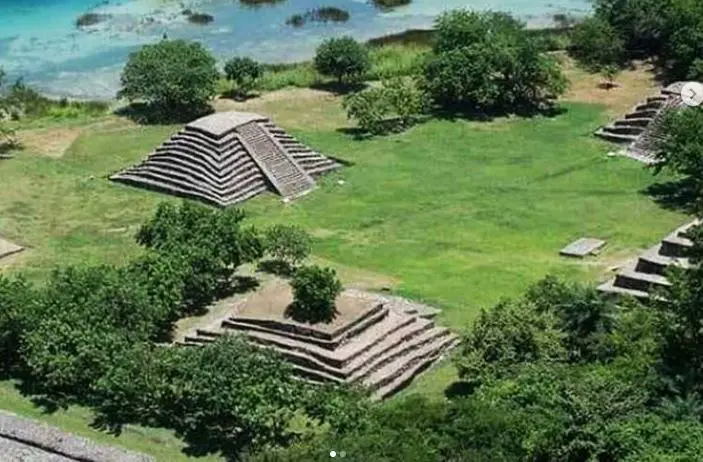
The Lagartero archaeological zone is located in the southeast part of the state of Chiapas, in the Municipio or County of La Trinitaria, near a small settlement named for Christopher Columbus called Cristóbal Colón. The ruins sit on a series of islands, amid lakes and streams in a tropical jungle. The region is known informally as Lagos de Colón or Lagos de Montebello. Comitán, an official Mexican “pueblo mágico” or “magical town,” is about an hour north of the ruins. Traveling south, the visitor must reach the small town of Cristóbal Cólon and go 20 minutes off the main highway to reach the archaeological zone. The site is located at the foot of the Sierra de los Cuchumatanes and just minutes from an undefined border with Guatemala which lies somewhere in the dense jungle east of the ruins. Much of the archaeological zone is found on 10 small islands and peninsulas that protrude into the aquifer space of the lakes. The notable islands are Cangrejo, Sabino, Hasam, Puente de Mora, and Búho. The central area of the site is located on El Limonal Island, the largest, so named because of its overabundance of lemon trees. There are many other small islands without local names where mounds have been reported and artifacts have been discovered. The entire archaeological zone is immersed in a system of marshes and lagoons fed by the waters of the Lagartero and San Lucas rivers which are upper tributaries of the Rio Grijalva. Natural springs also feed into the various ponds and lagoons. A series of waterfalls nearby provide weekend recreation to locals as they must have done in ancient times.
 The ruins of Lagartero have been ignored for centuries and it wasn’t until 1972 that Mexico’s National Institute of Anthropology and History, or INAH, took interest and gave the site its current name. Serious study began in the 1970s along with clearing away the vegetation from the main structures and plazas to make the way for future tourists. INAH did some restoration work on one of the main pyramids, but 3 of the pyramids have a sagging or “melting” appearance due to the stones used in construction. Visitors to the site are advised that because these limestone bricks came from the inside of cenotes or sinkholes that the material is weak and hard to source for replacement materials, so climbing on the so-called “melted” pyramids is prohibited. In the 21st Century there has been little interest paid to Lagartero by archaeologists, and this has a lot to do with funding issues and because the ruins are of moderate size and off the beaten path. As of this recording, the zone is now off limits to tourists due to staffing concerns, but locals can come and go as they please as they always have.
So, what does this “lost city” of “melted pyramids” look like and what’s it’s history? Lagartero was built by the ancient Maya with construction starting around 300 BC. The height of its greatest splendor was during what archaeologists call the Late Classic period from 700 to about 900 AD. Lagartero was probably an independent smaller-sized kingdom, but some researchers believe that it was subject to larger Maya city-states across its history. During the Classic Period, it served as an important link between the lowland Maya of Chiapas and the Maya kingdoms of the highlands of Guatemala. Some think that because of the springs, Lagartero may have served as a pilgrimage site or a place for healing. The pyramids, plazas and other structures along with the abundance of polychrome pottery found here, lead many researchers to believe the city served as a regional civic-ceremonial center. As little intense research has been done here, scholars are still trying to piece together an accurate timeline of this place and how it fit into the rest of the Maya landscape. Lagartero faced the same fate as the rest of the ancient Maya world, and after around 900 AD the city saw a slow abandonment. For many centuries squatters lived among the ruins and used the ample natural resources found in the 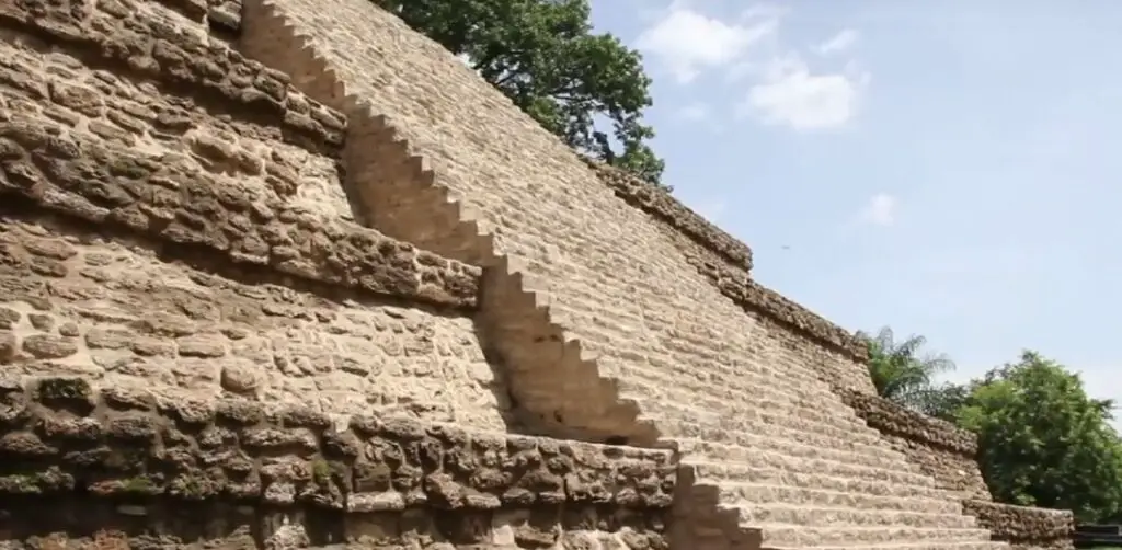 surrounding waters. By the time of the Aztec Empire’s domination over central Mexico, Lagartero became a busy city once again, although not the way it was hundreds of years before. The location was used as a stopover for travelers going between the Aztec homeland in the central Mexican highlands and the farthest-flung province of the Aztec Empire, a rich cacao-producing area called Xoconochco, located in modern-day Guatemala and Chiapas hugging the Pacific coast. For more information on Xoconochco, please see Mexico Unexplained Episode number 162: https://mexicounexplained.com/xoconochco-the-remotest-aztec-province/ It’s unknown whether the Aztecs had direct control over Lagartero in the 1300s and 1400s or if the city was just a friendly ally of the empire. Sometime in the 1400s Lagartero was abandoned a second time and by the time the Spanish arrived in the area in the early 1500s the city was overrun by jungle and had a few squatters living among the ruins once again.
The central heart of the city of Lagartero is located in the extreme north of El Limonal island. It is made up of altars, several small structures and six monumental buildings: pyramids 1, 2, 3 and 4, the ball court and a large platform. The main constructions consist of more than fifteen pyramids, the largest reaching a height of 36 feet. Most pyramids contained burials of elites discovered intact by archaeologists. The main area of the site also contains closed and open plazas, as well as various platforms of different sizes, some of which are interconnected or isolated. The civic-religious structures surround the plazas, while the residential buildings were extended around the lakes. No one knows the exact extent of the city as there has been very little formal research done in the surrounding jungle. As previously mentioned, in construction of these buildings workers used stone extracted from the cenotes, which is a type of soft and porous limestone. It is easy to work with, but it also erodes easily and is easy to destroy. Some temples that were built with this stone are now just piles of rubble that may never be restored. In the southern and eastern parts of the island of El Limonal, archaeologists found basements under houses and patios. No one knows the function of these underground rooms, although some have theorized that they were used to preserve food in the tropical climate. The ancient inhabitants of El Lagartero lived by cultivating corn, beans and on other plant and aquatic species.
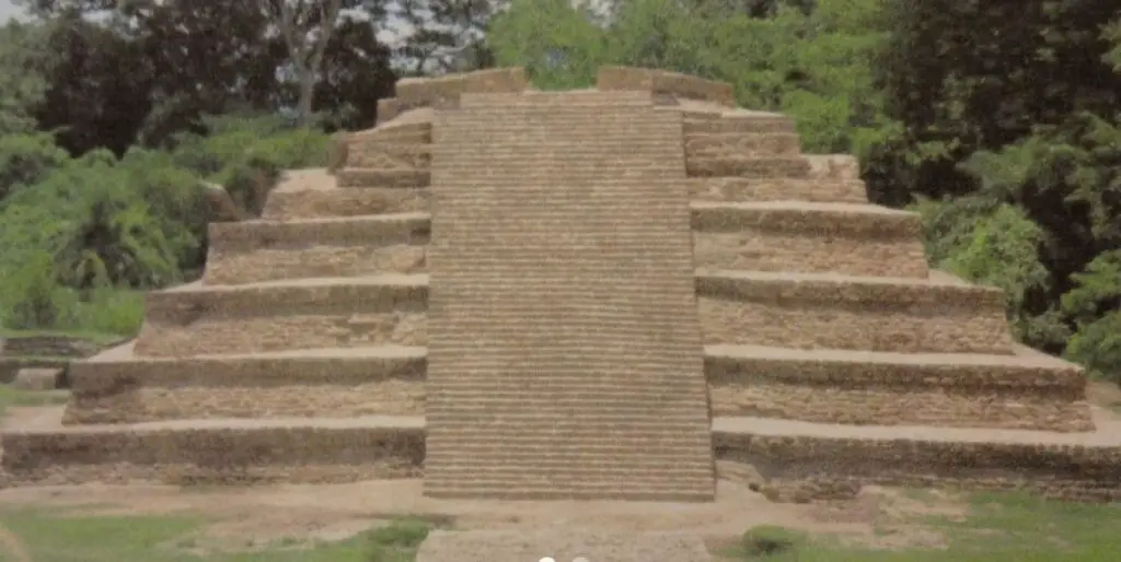 The last major excavation of this site was carried out in 2009 and archaeologists found some amazing things that they are still puzzling over. They discovered a carved stone monolith, or stela, dating back to the final days of the Classic Maya, which has a beautifully intact bas-relief carved with a scene of the seizure of power by one Mayan group over another. On the last level of Pyramid 4, the remains of two large bowls were found and near them a black vase with an animal-head lid that contained a rich offering of jadeite objects including two earmuffs, an articulated turtle, and several beads of necklace. In one of the tombs inside a Lagartero pyramid, archaeologists found a cache of funerary offerings of incredible variety. Among the items in the cache were copper pendants, an elaborately fashioned copper rattle, objects made of amber, pieces of pottery from various regions of ancient Mexico, and remnants of textiles well over a thousand years old. The most curious discovery in the 2009 field season was four lizard head pieces ceremonially buried. Although the name for the ruins – Lagartero, “the place of the lizards” – was given to the city in modern times, some researchers believe that this lizard head discovery confirms that the original name of the place must have alluded to lizards, which in turn were symbols of the underworld for the Maya. Perhaps this discovery was just a happy coincidence. The final chapter of this obscure and mysterious site has yet to be written. Maybe sometime soon researchers will better understand this city as the enigmatic ruins continue to give up their secrets.
REFERENCES
INAH web site